

By Grzegorz Sochacki, PhD Student at the University of Warsaw.
For several decades, archaeological research in both the Negev Highlands and southern Jordan has sought to reconstruct ancient agricultural practices. These investigations have relied primarily on the identification of ancient farmsteads and concentrations of agricultural infrastructure, allowing researchers to reconstruct past agricultural landscapes.
In January 2026, a short season of field survey was conducted in the Wadi al-Hasa region of southern Jordan. The survey represented the culmination of nearly six months of remote-sensing analyses aimed at understanding modern agricultural practices and their relationship to ancient farming traditions. The study area is characterized by highly varied topography, which largely prevents the creation of extensive, flat agricultural fields and large-scale irrigation systems typical of modern agriculture. As a result, local communities have historically adapted their farming strategies to the natural landscape rather than attempting to reshape it. Understanding these traditional land-use practices is therefore essential for interpreting both the modern and the ancient agricultural landscape of Wadi al-Hasa.
The aspect of remote-sensing combined satellite imagery with GIS-based spatial analyses to identify modern agricultural systems, employing methods comparable to those known from antiquity. Particular attention was given to agricultural terraces and stone retaining walls. GIS analyses focused on slope gradient, aspect, and access to water resources. These observations were subsequently verified through systematic field surveys conducted in selected locations.
A buffer zone with a radius of 6.5 km was established in the vicinity of the modern town of at-Tafileh, covering as much potentially arable land within the Wadi al-Hasa region as possible.
Based on the combined remote-sensing and field survey data, it was possible to establish a typology of modern agricultural systems reflecting the principles that also underpinned ancient farming practices. As in antiquity, access to water proved to be the primary factor determining the location and organisation of agricultural infrastructure. Although many contemporary farms employ modern irrigation technologies, such as plastic pipes distributing water from nearby reservoirs.
Four principal types of agricultural systems were identified within the Wadi al-Hasa region, providing a valuable framework for exploring both continuity and change in agricultural practices from antiquity to the present.
Type 1 – Hillslope terraces
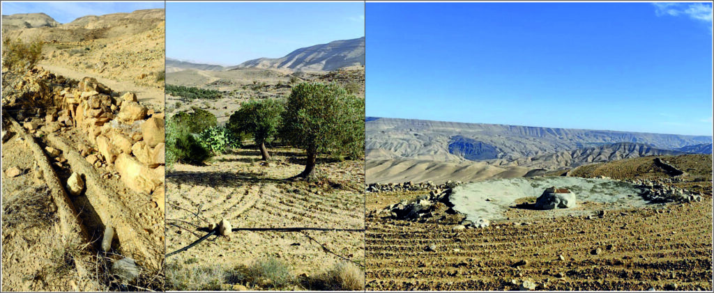
This is the most common type of agricultural installation identified during the survey. It consists of terraces constructed directly on hillslopes following the contour lines of the terrain. The system relies entirely on runoff flowing downslope from the hilltop towards the valley floor. This arrangement maximizes the cultivable surface while taking advantage of favourable slope exposure (fig. 1).
Today, these terraces are frequently supplemented by artificial irrigation, as indicated by plastic pipes and water reservoirs situated at the highest point of the cultivated area (Fig. 2).

Type 2 – U-shaped terraces
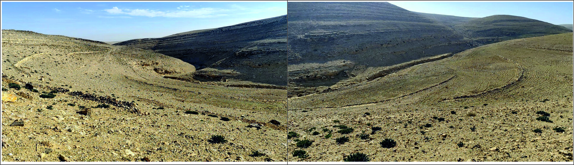
This type is based on semi-circular retaining walls built across the valley floor, with both ends pointing downstream in the direction of water flow (Fig. 3).
Such a configuration not only captures runoff, moving through the valley but also traps fertile alluvial sediments, creating highly productive cultivation areas. Additional retaining walls are often constructed on the adjacent valley slopes. These structures serve several purposes: they stabilise the slopes, reduce erosion, redirect runoff towards the valley floor, and retain water long enough for gradual infiltration into cultivated plots.

Type 3 – Stone-enclosed agricultural systems
This is a relatively uncommon type of agricultural installation (Fig. 4).
Historical evidence from the Negev Highlands suggests that enclosed agricultural systems of this kind were primarily associated with orchards, especially olive cultivation. Modern examples are known from the site of Khirbet edh-Dharih.

Type 4 – Combined agricultural infrastructure
The fourth category includes agricultural systems combining elements of multiple types, most commonly Types 1 and 2. Their development was favoured by topographic settings that allowed terraces to be constructed both on hillslopes and along the floor of small valleys (fig. 5).
This integrated strategy enabled the maximum exploitation of limited agricultural space, particularly where local conditions did not favour the exclusive development of a single terrace type.
Final remarks
The survey demonstrates that the fundamental principles governing terrace construction and agricultural land use have remained remarkably consistent over time. Modern cultivated fields continue to pursue the same objectives as their ancient predecessors: maximizing the productive use of available land while efficiently managing scarce water resources.
The most significant difference lies in the adoption of modern irrigation infrastructure, including concrete reservoirs, plastic pipelines, and concrete drainage channels, all designed to increase agricultural productivity. These technologies have made it possible to cultivate flat areas that are less dependent on natural runoff. Nevertheless, they have not replaced traditional farming techniques. In the study area, terrace-based agriculture remains both practical and effective, particularly for small-scale farming communities.
The research also revealed important similarities and equally significant differences between modern agricultural systems in Wadi al-Hasa and ancient farming landscapes known from the Southern Levant. In both regions, agricultural infrastructure was carefully adapted to local topography, while stone-enclosed fields were associated primarily with orchards and olive cultivation. In Wadi al-Hasa, however, terraces developed directly within valley floors are considerably more common than elsewhere. Characteristic retaining walls enable farmers not only to capture runoff but also to accumulate fertile alluvial sediments, substantially enhancing agricultural productivity.
I am grateful to CBRL and the Andrea Zerbini Award for funding this fieldwork, and to the Jordanian Department of Antiquities for their support and collaboration.
All photography by Grzegorz Sochacki
Biography
Grzegorz Sochacki is a PhD Student at the University of Warsaw, Poland. His research focuses on the use of ancient cooking pottery, the reconstruction of past diets, and their relationship to agricultural strategies in the ancient Levant. In 2025–2026, he was awarded the Andrea Zerbini Award for his research on modern agricultural practices in the Wadi al-Hasa region of southern Jordan.
The views expressed by our authors on the CBRL blog are not necessarily endorsed by CBRL but are commended as contributing to public debate.